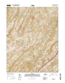
2016 Map of Greenville
USGS Topo · Published 2016About this map
Greenville and Middlebrook anchor this portion of Augusta County, where the Shenandoah Valley landscape is defined by the winding paths of Middle River and S River. The map reveals a community structured by deep-rooted family landmarks and rural infrastructure, from the prominent elevation of Sugarloaf and Stony Hill to the essential water source at Cockran Spring. Genealogists will find significant value in the distribution of burial sites across the township, including Glebe Cem, Oak Hill Cem, and the Greenville Cem near the southern settlement. The transportation network is a mixture of modern thoroughfares and lanes that likely follow historic property boundaries, such as Stover School Rd and McClures Mill Rd, which point to the area's earlier reliance on local education and milling. The presence of Walace Lake and various creeks like Folly Mills Cr and Christians Cr underscores the importance of the local watershed to the region's agricultural character.
Find a feature on this map
73 named features on this map. Tap any name to fly to it.
Don’t see what you’re looking for? This feature index may not catch every label — zoom into the map to look around manually.
Map Details
Editions of this 2016 Greenville Map
This is the sole edition of this map. No revisions or reprints were ever made.
Other maps of this area

1894 · Staunton
USGS Topo · 1:125,000

1894 · Lexington
USGS Topo · 1:125,000

1932 · Lexington
USGS Topo · 1:48,000

1936 · Vesuvius
USGS Topo · 1:48,000

1937 · Lexington
USGS Topo · 1:62,500

1941 · Vesuvius
USGS Topo · 1:62,500

1943 · Craigsville
USGS Topo · 1:62,500

1944 · Staunton
USGS Topo · 1:62,500

1945 · Craigsville
USGS Topo · 1:62,500

1947 · Staunton
USGS Topo · 1:62,500