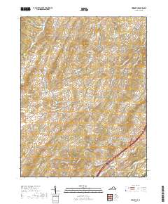
2019 Map of Greenville
USGS Topo · Published 2019About this map
The S River and the small valley settlement of Greenville anchor the southeastern corner of this landscape, where modern transportation corridors intersect with older rural routes like Old Greenville Rd and Howardsville Rd. Moving west into the hills, the terrain becomes more complex as the drainage systems of Roaring Run and Back Creek weave through the ridges. The community of Middlebrook is situated in this western portion, connected to the larger region by Middlebrook Rd. This topography is marked by several historical burials, including the Oak Hill Cem near Middlebrook and Glebe Cem to the north, which serve as lasting indicators of the area's early farmstead family history. To the northeast, Arbor Hill overlooks a network of minor waterways such as Smoky Row Cr and Folly Mills Cr, illustrating the dense distribution of family-named roads and landmarks like Sugarloaf that define this part of Augusta County.
Find a feature on this map
74 named features on this map. Tap any name to fly to it.
Don’t see what you’re looking for? This feature index may not catch every label — zoom into the map to look around manually.
Map Details
Editions of this 2019 Greenville Map
This is the sole edition of this map. No revisions or reprints were ever made.
Other maps of this area

1894 · Staunton
USGS Topo · 1:125,000

1894 · Lexington
USGS Topo · 1:125,000

1932 · Lexington
USGS Topo · 1:48,000

1936 · Vesuvius
USGS Topo · 1:48,000

1937 · Lexington
USGS Topo · 1:62,500

1941 · Vesuvius
USGS Topo · 1:62,500

1943 · Craigsville
USGS Topo · 1:62,500

1944 · Staunton
USGS Topo · 1:62,500

1945 · Craigsville
USGS Topo · 1:62,500

1947 · Staunton
USGS Topo · 1:62,500