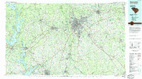
1984 Map of Greenville
USGS Topo · Published 1984About this map
Greenville and the surrounding Upstate region are shown here during a period of significant suburban expansion and industrial transition. The map captures the growing urban footprints of Anderson, Spartanburg, and Easley, linked by the critical corridor of Interstate 85. To the west, the massive reservoirs of Lake Keowee, Lake Jocassee, and Hartwell Lake dominate the landscape, illustrating the mid-century transformation of the Savannah River basin for hydroelectric power and recreation.
Find a feature on this map
145 named features on this map. Tap any name to fly to it.
Don’t see what you’re looking for? This feature index may not catch every label — zoom into the map to look around manually.
Map Details
Editions of this 1984 Greenville Map
This is the sole edition of this map. No revisions or reprints were ever made.
Other maps of this area

1886 · Walhalla
USGS Topo · 1:125,000

1888 · Pickens
USGS Topo · 1:125,000

1891 · Cowee
USGS Topo · 1:125,000

1891 · Carnesville
USGS Topo · 1:125,000

1892 · Walhalla
USGS Topo · 1:125,000

1892 · Abbeville
USGS Topo · 1:125,000

1893 · Elberton
USGS Topo · 1:125,000

1894 · Pickens
USGS Topo · 1:125,000

1896 · Walhalla
USGS Topo · 1:125,000

1897 · Cowee
USGS Topo · 1:125,000