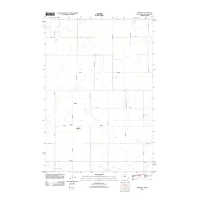
2012 Map of Greenway
USGS Topo · Published 2012About this map
Greenway and the nearby locale of Madra sit along the border between McPherson County and North Dakota, marking a quiet agricultural landscape defined by section lines and small family legacies. This region in the early 2000s remains largely unchanged in its rural character, with the township grid system dictating the flow of local travel along routes like 102nd St and 323rd Ave. Small water bodies and drainage basins dot the prairie north of Spring Cr, which winds across the southern reaches of the map. For those tracing regional roots, the presence of dedicated burial sites like Greenway Cem, Brenneise Cem, and Wolff Cem provides specific points of interest for genealogical research, anchoring family names to the physical landscape of the High Plains.
Find a feature on this map
28 named features on this map. Tap any name to fly to it.
Don’t see what you’re looking for? This feature index may not catch every label — zoom into the map to look around manually.
Map Details
Editions of this 2012 Greenway Map
This is the sole edition of this map. No revisions or reprints were ever made.
Other maps of this area
1953 · Jamestown
USGS Topo · 1:250,000
1954 · Aberdeen
USGS Topo · 1:250,000
1956 · Aberdeen
USGS Topo · 1:250,000
1956 · Jamestown
USGS Topo · 1:250,000
1978 · Greenway
USGS Topo · 1:24,000
1978 · Zeeland
USGS Topo · 1:24,000
1978 · Eureka West
USGS Topo · 1:24,000
1978 · Venturia
USGS Topo · 1:24,000
1978 · Eureka East
USGS Topo · 1:24,000
1978 · Mutske Lake
USGS Topo · 1:24,000