
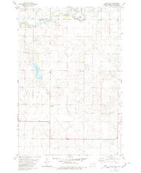
1978 Map of Greenway
USGS Topo · Published 1979About this map
The rolling plains along the North Dakota and South Dakota border define this 1970s survey, illustrating a landscape primarily dedicated to agriculture and the remnants of early rail connectivity. The small settlement of Madra stands as a focal point in the central portion of the quadrangle, situated along the corridor of the Chicago Milwaukee ST Paul And Pacific railroad. This transportation line historically linked these borderlands, facilitating the movement of grain and livestock across the prairie. The map shows the intricate drainage patterns of Spring Creek, which meanders through the southern half of the area, providing a natural contrast to the grid of section lines and rural roads that organize the high plains of McPherson and Campbell counties.
Find a feature on this map
1 named feature on this map. Tap any name to fly to it.
Don’t see what you’re looking for? This feature index may not catch every label — zoom into the map to look around manually.
Map Details
Editions of this 1978 Greenway Map
This is the sole edition of this map. No revisions or reprints were ever made.
Other maps of this area

1953 · Jamestown
USGS Topo · 1:250,000

1954 · Aberdeen
USGS Topo · 1:250,000

1956 · Aberdeen
USGS Topo · 1:250,000

1956 · Jamestown
USGS Topo · 1:250,000

1978 · Zeeland
USGS Topo · 1:24,000

1978 · Eureka West
USGS Topo · 1:24,000

1978 · Venturia
USGS Topo · 1:24,000

1978 · Eureka East
USGS Topo · 1:24,000

1978 · Mutske Lake
USGS Topo · 1:24,000
1980 · Hague SE
USGS Topo · 1:24,000