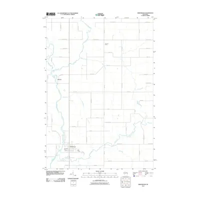
2010 Map of Greenwood
USGS Topo · Published 2010About this map
Greenwood serves as the primary hub of this central Wisconsin landscape, situated where Rock Creek meets the southward-flowing Black River. The 2010 survey details a well-established grid of rural roads and agricultural plots that define the region's character, including prominent landmarks like the Greenwood City Cemetery and Saint Marys Cemetery on the southeastern edge of town. North of the main settlement, the smaller community of Hemlock sits along a bend in the Black River, near the confluence with the Popple River. The terrain is defined by a dense network of tributaries including Behringer Creek and Gile Creek, which cut through the level terrain. Local aviation and utility are represented by the Town Line Airport, while a series of named roads like Popple River Road and Maple Center Road provide a granular view of the county's transportation network in the early 21st century.
Find a feature on this map
46 named features on this map. Tap any name to fly to it.
Don’t see what you’re looking for? This feature index may not catch every label — zoom into the map to look around manually.
Map Details
Editions of this 2010 Greenwood Map
This is the sole edition of this map. No revisions or reprints were ever made.
Other maps of this area

1953 · Neillsville
USGS Topo · 1:62,500

1953 · Abbotsford
USGS Topo · 1:48,000

1953 · Owen
USGS Topo · 1:48,000

1953 · Eau Claire
USGS Topo · 1:250,000

1954 · Granton
USGS Topo · 1:62,500

1958 · Eau Claire
USGS Topo · 1:250,000

1963 · Abbotsford
USGS Topo · 1:62,500

1963 · Owen
USGS Topo · 1:62,500

1964 · Eau Claire
USGS Topo · 1:250,000
1979 · Loyal East
USGS Topo · 1:24,000