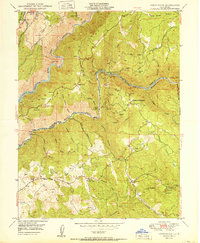
1950 Map of Greenwood
USGS Topo · Published 1950About this map
Greenwood and Spanish Dry Diggings anchor this 1950 portrait of the California Gold Country, where the deep canyons of the Middle Fork American River and North Fork American River define the landscape. The map reveals a post-war transition in El Dorado and Placer counties, showing the early stages of the Reservoir near Applegate alongside a dense network of older industrial sites. Numerous mining operations like the Grit Mine, Sliger Mine, and Oregon Bar Mine reflect the region's enduring mineral history. These sites are linked by a complex system of water infrastructure, including various ditches and flumes that served the hydraulic and hard-rock mines of the era. Smaller, isolated settlements such as Butcher Ranch, Grizzly Bear House, and Hoboken illustrate the scattered nature of early foothills habitation, while family-named sites like Penobscot Farm provide specific touchpoints for local genealogists.
Find a feature on this map
62 named features on this map. Tap any name to fly to it.
Don’t see what you’re looking for? This feature index may not catch every label — zoom into the map to look around manually.
Map Details
Editions of this 1950 Greenwood Map
This is the sole edition of this map. No revisions or reprints were ever made.
Other maps of this area

1888 · Smartsville
USGS Topo · 1:125,000

1891 · Sacramento
USGS Topo · 1:125,000

1891 · Colfax
USGS Topo · 1:125,000

1891 · Smartsville
USGS Topo · 1:125,000

1891 · Placerville
USGS Topo · 1:125,000

1892 · Sacramento
USGS Topo · 1:125,000

1892 · Placerville
USGS Topo · 1:125,000

1892 · Smartsville
USGS Topo · 1:125,000

1892 · Colfax
USGS Topo · 1:125,000

1893 · Placerville
USGS Topo · 1:125,000