
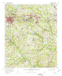
1957 Map of Greer
USGS Topo · Published 1959About this map
The Middle Tyger River and South Tyger River systems define the industrial and residential development of this Upstate landscape in the late 1950s. Centered on Greer, the map highlights the proximity of industry to settlement, with Victor Mills and Startex anchoring significant population clusters. The Southern and Northern railway lines parallel the river valleys, connecting larger towns like Wellford and Lyman to the broader regional economy.
Find a feature on this map
125 named features on this map. Tap any name to fly to it.
Don’t see what you’re looking for? This feature index may not catch every label — zoom into the map to look around manually.
Map Details
Editions of this 1957 Greer Map
2 editions found
Other maps of this area

1907 · Saluda
USGS Topo · 1:125,000

1935 · Greer
USGS Topo · 1:48,000

1935 · Greenville
USGS Topo · 1:48,000

1938 · Greenville
USGS Topo · 1:62,500

1938 · Greer
USGS Topo · 1:62,500

1941 · Spartanburg
USGS Topo · 1:250,000

1947 · Spartanburg
USGS Topo · 1:62,500

1949 · Spartanburg
USGS Topo · 1:24,000

1949 · Spartanburg
USGS Topo · 1:62,500

1953 · Spartanburg
USGS Topo · 1:250,000