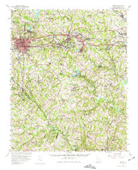
1957 Map of Greer
USGS Topo · Published 1974About this map
Greer and the textile-producing corridor of the South Carolina Upstate appear here during a period of post-war industrial expansion. The map detail reflects the significance of the Southern and Piedmont and Northern railroads, which facilitated the growth of mill towns like Lyman, Startex, and Victor Mills. The landscape is intricately defined by the three branches of the Tyger River—the North Tyger River, Middle Tyger River, and South Tyger River—which provided the water power and geographical structure for early industrialization. Local life is centered around institutions such as Davenport High Sch and Washington Ch, alongside newer recreational landmarks like the Greer Country Club. The transition from rural farmland to a more interconnected suburban and industrial landscape is evident in the burgeoning residential clusters of Fairmont, Wellford, and Reidville, all linked by an evolving network of roads and rails.
Find a feature on this map
127 named features on this map. Tap any name to fly to it.
Don’t see what you’re looking for? This feature index may not catch every label — zoom into the map to look around manually.
Map Details
Editions of this 1957 Greer Map
2 editions found

Other maps of this area

1907 · Saluda
USGS Topo · 1:125,000

1935 · Greer
USGS Topo · 1:48,000

1935 · Greenville
USGS Topo · 1:48,000

1938 · Greenville
USGS Topo · 1:62,500

1938 · Greer
USGS Topo · 1:62,500

1941 · Spartanburg
USGS Topo · 1:250,000

1947 · Spartanburg
USGS Topo · 1:62,500

1949 · Spartanburg
USGS Topo · 1:24,000

1949 · Spartanburg
USGS Topo · 1:62,500

1953 · Spartanburg
USGS Topo · 1:250,000