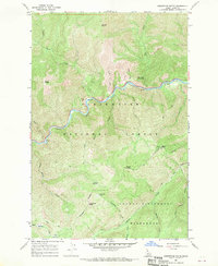
1966 Map of Greystone Butte
USGS Topo · Published 1969About this map
The Lochsa River carves a deep path through this mid-1960s Idaho landscape, serving as the primary corridor for movement through the Clearwater National Forest. Along its northern banks, Weir Creek Hot Springs represents a notable geothermal feature near the mouth of Weir Creek. The terrain is defined by high ridgelines and peaks such as Ashpile Peak and Grave Butte, while human presence is marked by a remote Lookout Tower on Mocus Point and a small Borrow Pit near the river bend.
Find a feature on this map
32 named features on this map. Tap any name to fly to it.
Don’t see what you’re looking for? This feature index may not catch every label — zoom into the map to look around manually.
Map Details
Editions of this 1966 Greystone Butte Map
2 editions found
Other maps of this area

1911 · Lolo
USGS Topo · 1:250,000

1913 · Lolo
USGS Topo · 1:250,000

1956 · Hamilton
USGS Topo · 1:250,000

1959 · Hamilton
USGS Topo · 1:250,000

1960 · Hamilton
USGS Topo · 1:250,000

1964 · Hamilton
USGS Topo · 1:250,000

1965 · Lookout Peak
USGS Topo · 1:24,000

1965 · Horseshoe Lake
USGS Topo · 1:24,000

1966 · Mc Connell Mtn
USGS Topo · 1:24,000
1966 · Bear Mountain
USGS Topo · 1:24,000