
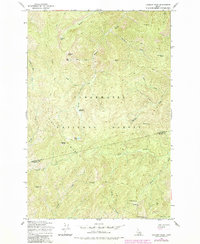
1965 Map of Lookout Peak
USGS Topo · Published 1967About this map
Clearwater National Forest dominates this mid-1960s landscape, where the high ridges of north-central Idaho form a boundary between Clearwater Co and Idaho Co. The map reveals a wild, backcountry network of pack trails and mountain passes that served as the primary infrastructure for forest management and seasonal movement before modern road development. High-altitude landmarks like Lookout Peak and Porphyry Peak stand over remote water bodies including Lookout Lake, Gem Lake, and Monroe Lake. The presence of Little Cabin Meadows and Windy Ridge Camp suggests the early use of this terrain by forest rangers and pack strings. Drainages such as Gem Creek and Raspberry Creek carve deep into the topography, illustrating the complex hydrology of the Windy Ridge area. This survey, based on 1959 aerial photography, documents the region's wilderness state at the height of 20th-century federal forest administration.
Find a feature on this map
33 named features on this map. Tap any name to fly to it.
Don’t see what you’re looking for? This feature index may not catch every label — zoom into the map to look around manually.
Map Details
Editions of this 1965 Lookout Peak Map
2 editions found
Other maps of this area

1911 · Lolo
USGS Topo · 1:250,000

1913 · Lolo
USGS Topo · 1:250,000

1956 · Hamilton
USGS Topo · 1:250,000

1959 · Hamilton
USGS Topo · 1:250,000

1960 · Hamilton
USGS Topo · 1:250,000

1964 · Hamilton
USGS Topo · 1:250,000

1965 · Junction Mtn
USGS Topo · 1:24,000

1965 · Scurvy Mtn.
USGS Topo · 1:24,000

1965 · Gorman Hill
USGS Topo · 1:24,000
1965 · Cook Mountain
USGS Topo · 1:24,000