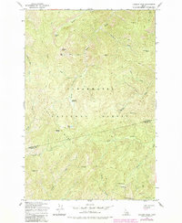
1965 Map of Lookout Peak
USGS Topo · Published 1984About this map
Clearwater National Forest defines this high-elevation backcountry during a period of active resource management and trail expansion. The 1965 survey, updated in 1984, shows a complex network of pack trails threading through the Bitterroot mountains, connecting established backcountry outposts like Little Cabin Meadows and Windy Ridge Camp. The terrain is characterized by prominent high points such as Lookout Peak and Monroe Butte, with drainage basins feeding numerous named waterways including Fourth of July Creek and Shin Tangle Creek. Historical movement through the region is evidenced by the positioning of 12 Mile Saddle and The Smoke Hole Camp, markers of the seasonal travel and wilderness monitoring that predated modern infrastructure in this corner of Idaho.
Find a feature on this map
35 named features on this map. Tap any name to fly to it.
Don’t see what you’re looking for? This feature index may not catch every label — zoom into the map to look around manually.
Map Details
Editions of this 1965 Lookout Peak Map
2 editions found
Other maps of this area

1911 · Lolo
USGS Topo · 1:250,000

1913 · Lolo
USGS Topo · 1:250,000

1956 · Hamilton
USGS Topo · 1:250,000

1959 · Hamilton
USGS Topo · 1:250,000

1960 · Hamilton
USGS Topo · 1:250,000

1964 · Hamilton
USGS Topo · 1:250,000

1965 · Junction Mtn
USGS Topo · 1:24,000

1965 · Scurvy Mtn.
USGS Topo · 1:24,000

1965 · Gorman Hill
USGS Topo · 1:24,000

1965 · Lookout Peak
USGS Topo · 1:24,000