
1965 Map of Scurvy Mtn.
USGS Topo · Published 1967About this map
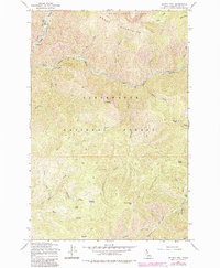
Clearwater National Forest dominates this mid-century topographic study, revealing a landscape defined by sharp elevation shifts and an extensive network of waterways and pack trails. The Clearwater River cuts through the northwest corner, joined by the winding Kelly Creek, which serves as a central drainage artery for the surrounding Moose Mountains. This era of management by the U.S. Forest Service is evidenced by the focus on fire observation and back-country access, highlighted by the Scurvy Mtn Lookout and the Junction Creek Pack Bridge. High-altitude features like Scurvy Saddle, Windy Bill Saddle, and Paradise Meadows suggest the seasonal routes used by foresters and early recreationists. The mapping of Pony Flats and Switchback Hill underscores the difficulty of navigating this terrain before modern road development.
Find a feature on this map
40 named features on this map. Tap any name to fly to it.
Don’t see what you’re looking for? This feature index may not catch every label — zoom into the map to look around manually.
Map Details
Editions of this 1965 Scurvy Mtn. Map
2 editions found
Other maps of this area

1911 · Lolo
USGS Topo · 1:250,000

1913 · Lolo
USGS Topo · 1:250,000

1956 · Hamilton
USGS Topo · 1:250,000

1959 · Hamilton
USGS Topo · 1:250,000

1960 · Hamilton
USGS Topo · 1:250,000
1963 · Elizabeth Lake
USGS Topo · 1:24,000

1964 · Hamilton
USGS Topo · 1:250,000

1965 · Osier Ridge
USGS Topo · 1:24,000

1965 · Junction Mtn
USGS Topo · 1:24,000
1965 · Moose Mtn
USGS Topo · 1:24,000