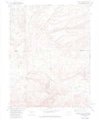
1983 Map of Gribbles Park
USGS Topo · Published 1983About this map
San Isabel National Forest encompasses much of this high-altitude landscape where the boundary between Park and Fremont counties splits the terrain. The map details a cattle-working environment, specifically noted by the presence of the Everett Cow Camp near the center of the sheet. Water sources are vital in this region, with numerous named springs and drainages such as Suckerville Spring, Steer Mud Spring, and Cals Fork Gulch providing the necessary resources for livestock and wildlife across the broad openings of Herring Park and Gribbles Park.
Find a feature on this map
25 named features on this map. Tap any name to fly to it.
Don’t see what you’re looking for? This feature index may not catch every label — zoom into the map to look around manually.
Map Details
Editions of this 1983 Gribbles Park Map
2 editions found
Other maps of this area

1954 · Pueblo
USGS Topo · 1:250,000

1956 · Cameron Mountain
USGS Topo · 1:62,500

1957 · Pueblo
USGS Topo · 1:250,000

1958 · Pueblo
USGS Topo · 1:250,000

1959 · Antero Reservoir
USGS Topo · 1:62,500

1959 · Black Mountain
USGS Topo · 1:62,500

1959 · Guffey
USGS Topo · 1:62,500

1962 · Pueblo
USGS Topo · 1:250,000

1966 · Pueblo
USGS Topo · 1:250,000
1983 · Jack Hall Mountain
USGS Topo · 1:24,000