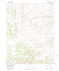
1983 Map of Gribbles Park
USGS Topo · Published 1983About this map
Gribbles Park and the surrounding high-altitude drainage basins define this portion of the Colorado landscape along the Park and Fremont County border. The map documents a sparsely populated ranching and mining environment during the late twentieth century, centered around water sources like Suckerville Spring and the Everett Cow Camp. The presence of numerous Prospect locations and a Mine suggests continued interest in the mineral potential of the area, while the San Isabel National Forest boundary marks the transition into protected lands. Navigation through this drainage-cut terrain is facilitated by primitive routes, including the Ute Trail and various Jeep Trails, which follow the natural contours carved by Wagon Tongue Creek and Badger Creek. The hydrology is particularly detailed, noting specialized features like Steer Mud Spring and Mud Spring alongside Gribbles Run.
Find a feature on this map
25 named features on this map. Tap any name to fly to it.
Don’t see what you’re looking for? This feature index may not catch every label — zoom into the map to look around manually.
Map Details
Editions of this 1983 Gribbles Park Map
2 editions found
Other maps of this area

1954 · Pueblo
USGS Topo · 1:250,000

1956 · Cameron Mountain
USGS Topo · 1:62,500

1957 · Pueblo
USGS Topo · 1:250,000

1958 · Pueblo
USGS Topo · 1:250,000

1959 · Antero Reservoir
USGS Topo · 1:62,500

1959 · Black Mountain
USGS Topo · 1:62,500

1959 · Guffey
USGS Topo · 1:62,500

1962 · Pueblo
USGS Topo · 1:250,000

1966 · Pueblo
USGS Topo · 1:250,000
1983 · Jack Hall Mountain
USGS Topo · 1:24,000