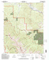
1994 Map of Wellsville
USGS Topo · Published 1998About this map
The Arkansas River cuts through the northern reaches of this Colorado high-country landscape, where the settlement of Wellsville serves as a lone point of habitation amidst an intensive network of mining operations. Dozens of Quarries, Mines, and Prospects are scattered across the terrain, particularly concentrated near Maverick Gulch and Taylor Gulch. This industry contrasts sharply with the vast protected lands to the south, where the Sangre De Cristo Wilderness and Rainbow Wilderness preserve the high peaks of the Sangre de Cristo Range. High-altitude landmarks like Simmons Peak and Hunts Peak overlook remote alpine waters, including Salamander Lake and Hunts Lake. The intersection of multiple jurisdictions is evident where the San Isabel National Forest and Rio Grande National Forest meet the boundaries of Chaffee, Fremont, and Saguache counties.
Find a feature on this map
46 named features on this map. Tap any name to fly to it.
Don’t see what you’re looking for? This feature index may not catch every label — zoom into the map to look around manually.
Map Details
Editions of this 1994 Wellsville Map
This is the sole edition of this map. No revisions or reprints were ever made.
Other maps of this area

1954 · Pueblo
USGS Topo · 1:250,000

1956 · Cameron Mountain
USGS Topo · 1:62,500

1956 · Poncha Springs
USGS Topo · 1:62,500

1956 · Montrose
USGS Topo · 1:250,000

1957 · Pueblo
USGS Topo · 1:250,000

1958 · Pueblo
USGS Topo · 1:250,000

1959 · Montrose
USGS Topo · 1:250,000

1959 · Bonanza
USGS Topo · 1:62,500

1959 · Howard
USGS Topo · 1:62,500

1960 · Montrose
USGS Topo · 1:250,000