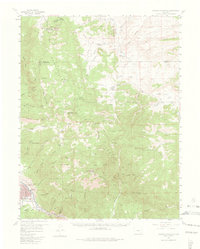
1956 Map of Cameron Mountain
USGS Topo · Published 1974About this map
Salida and the nearby settlement of Cleora sit at the southwestern corner of this survey, where the Arkansas River and South Arkansas River converge. The landscape is defined by the industrial and academic imprints of the mid-1950s, featuring the Oklahoma State University Engineering Camp and various resource extraction sites such as the Golden Wonder Mine and the Federal Quarry. The Denver and Rio Grande Western railroad tracks follow the river's curve, illustrating the transport corridor's importance to the regional economy.
Find a feature on this map
87 named features on this map. Tap any name to fly to it.
Don’t see what you’re looking for? This feature index may not catch every label — zoom into the map to look around manually.
Map Details
Editions of this 1956 Cameron Mountain Map
4 editions found
Other maps of this area

1954 · Pueblo
USGS Topo · 1:250,000

1955 · Buena Vista
USGS Topo · 1:62,500

1956 · Cameron Mountain
USGS Topo · 1:62,500

1956 · Poncha Springs
USGS Topo · 1:62,500

1956 · Montrose
USGS Topo · 1:250,000

1957 · Pueblo
USGS Topo · 1:250,000

1958 · Pueblo
USGS Topo · 1:250,000

1959 · Montrose
USGS Topo · 1:250,000

1959 · Bonanza
USGS Topo · 1:62,500

1959 · Antero Reservoir
USGS Topo · 1:62,500