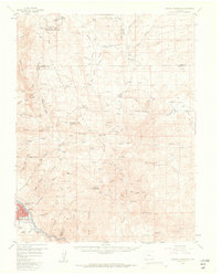
1956 Map of Cameron Mountain
USGS Topo · Published 1963About this map
Salida serves as the focal point of this mid-century survey, positioned along the banks of the Arkansas River where the Denver and Rio Grande Western railroad corridor follows the water's edge. This area of Fremont and Chaffee counties is defined by a dense network of gulches and ridges, including Aspen Ridge and Chaffee Ridge, which separate various high-altitude grazing and mining operations. Traces of early 20th-century life are visible at Whitehorn and through numerous family landmarks like Fehling Ranch and Minnman Ranch.
Find a feature on this map
83 named features on this map. Tap any name to fly to it.
Don’t see what you’re looking for? This feature index may not catch every label — zoom into the map to look around manually.
Map Details
Editions of this 1956 Cameron Mountain Map
4 editions found
Other maps of this area

1954 · Pueblo
USGS Topo · 1:250,000

1955 · Buena Vista
USGS Topo · 1:62,500

1956 · Cameron Mountain
USGS Topo · 1:62,500

1956 · Poncha Springs
USGS Topo · 1:62,500

1956 · Montrose
USGS Topo · 1:250,000

1957 · Pueblo
USGS Topo · 1:250,000

1958 · Pueblo
USGS Topo · 1:250,000

1959 · Montrose
USGS Topo · 1:250,000

1959 · Bonanza
USGS Topo · 1:62,500

1959 · Antero Reservoir
USGS Topo · 1:62,500