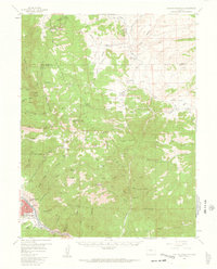
1956 Map of Cameron Mountain
USGS Topo · Published 1963About this map
Salida serves as a primary hub in the south-central portion of this mid-century survey, where the Denver and Rio Grande Western railroad parallels the Arkansas River. The landscape to the north is a complex network of high peaks and gulches, including Cameron Mountain and Jack Rabbit Hill. This era shows a mix of educational and ranching activity, evidenced by the Oklahoma State University Engineering Camp and various cattle-raising outposts like Everett Cow Camp and Fehling Ranch. The presence of the Golden Wonder Mine and Whitehorn indicates the region's long-standing connection to mineral extraction, while the San Isabel National Forest boundary defines the protected timberlands. Numerous springs, such as Manoa Springs and Black Diamond Spring, are noted throughout the gulches, suggesting the critical importance of water sources in this high-elevation terrain.
Find a feature on this map
81 named features on this map. Tap any name to fly to it.
Don’t see what you’re looking for? This feature index may not catch every label — zoom into the map to look around manually.
Map Details
Editions of this 1956 Cameron Mountain Map
4 editions found
Other maps of this area

1954 · Pueblo
USGS Topo · 1:250,000

1955 · Buena Vista
USGS Topo · 1:62,500

1956 · Cameron Mountain
USGS Topo · 1:62,500

1956 · Poncha Springs
USGS Topo · 1:62,500

1956 · Montrose
USGS Topo · 1:250,000

1957 · Pueblo
USGS Topo · 1:250,000

1958 · Pueblo
USGS Topo · 1:250,000

1959 · Montrose
USGS Topo · 1:250,000

1959 · Bonanza
USGS Topo · 1:62,500

1959 · Antero Reservoir
USGS Topo · 1:62,500