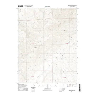
2016 Map of Phantom Canyon
USGS Topo · Published 2016About this map
Adelaide sits at the heart of this rugged Fremont County landscape, situated along the steep winding corridors of Phantom Canyon. The area is defined by a complex drainage network where Eightmile Cr and its eastern fork carve through the high terrain. These deep canyons provided natural conduits for travel, evidenced by the modern placement of Co RD 67 and Co RD 132, which follow the ancient watercourses. To the east, the elevation rises toward Table Mtn and Sugar Loaf, while the southeastern corner reveals a more community-focused development at Soda Springs Park. Genealogists may find particular interest in the Upper Beaver Cem, which stands as a quiet marker of the families who settled this challenging canyon country. The map captures the distinct character of Colorado's front range, where isolated settlements and landmarks like Trail Gulch and Box Canyon are etched into the earth by the force of Beaver Cr and its tributaries.
Find a feature on this map
28 named features on this map. Tap any name to fly to it.
Don’t see what you’re looking for? This feature index may not catch every label — zoom into the map to look around manually.
Map Details
Editions of this 2016 Phantom Canyon Map
This is the sole edition of this map. No revisions or reprints were ever made.
Other maps of this area

1889 · Canon City
USGS Topo · 1:125,000

1891 · Pueblo
USGS Topo · 1:125,000

1892 · Canon City
USGS Topo · 1:125,000

1893 · Colorado Springs
USGS Topo · 1:125,000

1894 · Pikes Peak
USGS Topo · 1:125,000

1894 · Pueblo
USGS Topo · 1:125,000

1896 · Pueblo
USGS Topo · 1:125,000

1897 · Pueblo
USGS Topo · 1:125,000

1901 · Pikes Peak
USGS Topo · 1:125,000

1909 · Colorado Springs
USGS Topo · 1:125,000