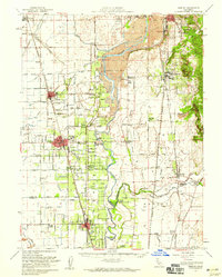
1952 Map of Gridley
USGS Topo · Published 1959About this map
Dredge tailings along the Feather River reveal the industrial footprint of post-gold rush gravel operations in this mid-century survey of the Sacramento Valley. The agricultural landscape is meticulously mapped through an extensive network of irrigation canals, including the Cherokee Canal and Butte County Canal, which support orchards and fields around the hubs of Gridley and Live Oak. This period shows a transition from rural ranching to more intensive cultivation, anchored by facilities like the Farm Labor Supply Center and the Manzanita Fire Sta.
Find a feature on this map
104 named features on this map. Tap any name to fly to it.
Don’t see what you’re looking for? This feature index may not catch every label — zoom into the map to look around manually.
Map Details
Editions of this 1952 Gridley Map
2 editions found
Other maps of this area

1888 · Marysville
USGS Topo · 1:125,000

1888 · Smartsville
USGS Topo · 1:125,000

1888 · Bidwell Bar
USGS Topo · 1:125,000

1891 · Bidwell Bar
USGS Topo · 1:125,000

1891 · Chico
USGS Topo · 1:125,000

1891 · Marysville
USGS Topo · 1:125,000

1891 · Smartsville
USGS Topo · 1:125,000

1892 · Smartsville
USGS Topo · 1:125,000

1893 · Chico
USGS Topo · 1:125,000

1893 · Bidwell Bar
USGS Topo · 1:125,000