
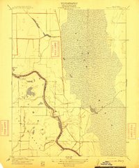
1911 Map of Grimes
USGS Topo · Published 1911About this map
The Sacramento River meanders sharply through the heart of this landscape, defining the boundary between Sutter and Colusa Counties during the early twentieth century. The settlement of Grimes serves as a primary riverfront hub, while the nearby Rancheria reflects the complex cultural history of the Sacramento Valley. This survey reveals a terrain defined by its complex hydrology, where numerous waterways like Corbiere Slough, Sycamore Slough, and Dry Slough drain the land toward the river. Low-lying depressions form distinctive water bodies such as Cecil Lake and Sills Lake. Along the riverbanks, features like Twentymile Bar and Gravel Pt indicate the shifting nature of the river channel, while the Montezuma Hills rise to the west. Infrastructure is represented by the Hannum Bridge, providing a critical crossing over the slough network that dominates the valley floor.
Find a feature on this map
15 named features on this map. Tap any name to fly to it.
Don’t see what you’re looking for? This feature index may not catch every label — zoom into the map to look around manually.
Map Details
Editions of this 1911 Grimes Map
This is the sole edition of this map. No revisions or reprints were ever made.
Other maps of this area

1888 · Marysville
USGS Topo · 1:125,000

1891 · Marysville
USGS Topo · 1:125,000

1894 · Marysville
USGS Topo · 1:125,000

1895 · Marysville
USGS Topo · 1:125,000

1905 · Harrington
USGS Topo · 1:24,000

1907 · Dunnigan
USGS Topo · 1:62,500

1907 · Colusa
USGS Topo · 1:62,500

1912 · Marysville Buttes
USGS Topo · 1:31,680

1912 · Meridian
USGS Topo · 1:31,680
1912 · Tisdale Weir
USGS Topo · 1:31,680