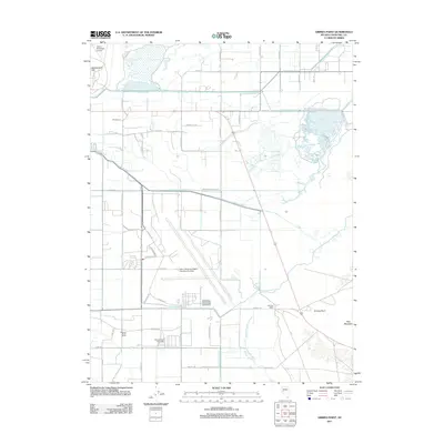
2011 Map of Grimes Point
USGS Topo · Published 2011About this map
Fallon Naval Air Sta, including Van Voorhis Field, dominates the central corridor of this Churchill County landscape, illustrating the significant military footprint in the high desert at the start of the 2010s. The region's agricultural and ranching heritage is preserved through features such as the Wallace-Taylor Ranch and Nevada Feed and Cattle, alongside an intricate irrigation network of the S Line, R Line, and L Line canals. These waterways feed the Harmon Reservoir and S Line Reservoir, essential for sustaining the area's arid valley economy. Geologic landmarks like Rattlesnake Hill and Eetz Mountain provide natural anchors, while the Hill Post Office and the ancient petroglyph site near Grimes Point mark different eras of human habitation and communication. The map also delineates drainage patterns through Grimes Slough and Old River Slough, showing the intersection of natural hydrology and man-made reclamation.
Find a feature on this map
49 named features on this map. Tap any name to fly to it.
Don’t see what you’re looking for? This feature index may not catch every label — zoom into the map to look around manually.
Map Details
Editions of this 2011 Grimes Point Map
This is the sole edition of this map. No revisions or reprints were ever made.
Other maps of this area

1908 · Carson Sink
USGS Topo · 1:250,000

1910 · Carson Sink
USGS Topo · 1:250,000

1950 · Stillwater
USGS Topo · 1:62,500

1951 · Carson Lake
USGS Topo · 1:62,500

1951 · Soda Lake
USGS Topo · 1:62,500

1951 · Fallon
USGS Topo · 1:62,500

1957 · Reno
USGS Topo · 1:250,000

1959 · Reno
USGS Topo · 1:250,000

1960 · Reno
USGS Topo · 1:250,000

1979 · Carson Sink
USGS Topo · 1:100,000