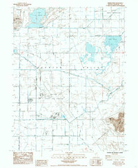
1985 Map of Grimes Point
USGS Topo · Published 1985About this map
Lahontan Valley defines this landscape of irrigation and military infrastructure in the mid-1980s. The sprawling Fallon Naval Air Station occupies a significant portion of the terrain, featuring numerous radio facilities and a central control tower. The surrounding area is a complex network of man-made waterways and natural drainages, including S Line Reservoir, Harmon Reservoir, and Stillwater Slough, which support the local agriculture. Cultural landmarks such as the Harmon School and the Churchill Co Cemetery provide important points for genealogical research. To the east, the terrain rises sharply toward Eetz Mountain and Grimes Point, where a historical marker indicates the intersection of desert topography and local heritage. The grid of rural roads, including Macari Lane and Berney Road, illustrates the late-20th-century settlement pattern in this arid Nevada basin.
Find a feature on this map
35 named features on this map. Tap any name to fly to it.
Don’t see what you’re looking for? This feature index may not catch every label — zoom into the map to look around manually.
Map Details
Editions of this 1985 Grimes Point Map
This is the sole edition of this map. No revisions or reprints were ever made.
Other maps of this area

1908 · Carson Sink
USGS Topo · 1:250,000

1910 · Carson Sink
USGS Topo · 1:250,000

1950 · Stillwater
USGS Topo · 1:62,500

1951 · Carson Lake
USGS Topo · 1:62,500

1951 · Soda Lake
USGS Topo · 1:62,500

1951 · Fallon
USGS Topo · 1:62,500

1957 · Reno
USGS Topo · 1:250,000

1959 · Reno
USGS Topo · 1:250,000

1960 · Reno
USGS Topo · 1:250,000

1979 · Carson Sink
USGS Topo · 1:100,000