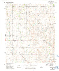
1988 Map of Grimes
USGS Topo · Published 1989About this map
Middle Buffalo Creek and Starvation Creek cut through the undulating plains of western Oklahoma in this late twentieth-century landscape, where the rural economy is defined by energy extraction and agriculture. The map documents a dense network of Gas Wells and Drill Holes that dot the terrain, showing the extent of the region's petroleum development. Scattered social centers serve as the anchors for local history, including the Sunny Point Community Center and the small settlement at Grimes. For those researching family history, several burial grounds are preserved across the quadrangle, such as Brookside Cemetery and Wayland Cemetery. The intersection of Roger Mills and Beckham counties is clearly delineated, providing a precise geographic context for the local Buffalo Church and the adjacent Buffalo Cemetery.
Find a feature on this map
21 named features on this map. Tap any name to fly to it.
Don’t see what you’re looking for? This feature index may not catch every label — zoom into the map to look around manually.
Map Details
Editions of this 1988 Grimes Map
This is the sole edition of this map. No revisions or reprints were ever made.
Other maps of this area

1955 · Clinton
USGS Topo · 1:250,000

1957 · Clinton
USGS Topo · 1:250,000

1960 · Sweetwater
USGS Topo · 1:62,500

1960 · Cheyenne
USGS Topo · 1:62,500

1960 · Sayre
USGS Topo · 1:62,500

1961 · Reydon
USGS Topo · 1:62,500

1984 · Foss Reservoir
USGS Topo · 1:100,000

1985 · Elk City
USGS Topo · 1:100,000

1988 · Dempsey
USGS Topo · 1:24,000
1989 · Prentiss
USGS Topo · 1:24,000