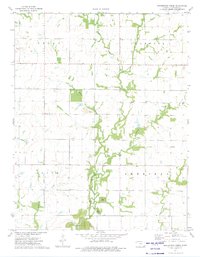
1973 Map of Grindstone Creek
USGS Topo · Published 1975About this map
Lightning Creek and Grindstone Creek carve through this rural landscape on the border of Crawford and Neosho counties, where small agricultural communities and local industry defined the early 1970s. The map reveals a cluster of rural nodes like Greenbush and Michael, alongside community centers such as Lebanon Ch and Round Prairie Ch. These points of assembly, often paired with burial grounds like Mt Carmel Cem or Meyers Cem, provide essential data for genealogists tracing family ties in the region.
Find a feature on this map
25 named features on this map. Tap any name to fly to it.
Don’t see what you’re looking for? This feature index may not catch every label — zoom into the map to look around manually.
Map Details
Editions of this 1973 Grindstone Creek Map
This is the sole edition of this map. No revisions or reprints were ever made.
Other maps of this area

1884 · Fort Scott
USGS Topo · 1:125,000

1886 · Joplin
USGS Topo · 1:125,000

1886 · Iola
USGS Topo · 1:125,000

1886 · Fort Scott
USGS Topo · 1:125,000

1886 · Parsons
USGS Topo · 1:125,000

1893 · Fort Scott
USGS Topo · 1:125,000
1893 · Iola
USGS Topo · 1:125,000

1893 · Parsons
USGS Topo · 1:125,000

1894 · Joplin
USGS Topo · 1:125,000

1904 · Iola
USGS Topo · 1:125,000