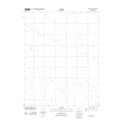
2012 Map of Grinnell NE
USGS Topo · Published 2012About this map
The Saline River and its accompanying drainage systems define this landscape in the western Kansas plains. Meandering through the central and southern portions of the quadrangle, the river is supported by smaller tributaries like Spring Brook Cr, which cuts diagonally across the northern half. This area, located northeast of Grinnell, showcases the typical grid-based development of the region, where rural life is organized along established thoroughfares such as Road 80W and Road 90S. In the extreme southern reach of the map, the headwaters of N Fork Big Cr appear, marking a subtle divide in the local hydrology. This topographic study reflects the persistent rural character and agricultural layout of Gove County in the early 21st century.
Find a feature on this map
5 named features on this map. Tap any name to fly to it.
Don’t see what you’re looking for? This feature index may not catch every label — zoom into the map to look around manually.
Map Details
Editions of this 2012 Grinnell NE Map
This is the sole edition of this map. No revisions or reprints were ever made.
Other maps of this area

1954 · Goodland
USGS Topo · 1:250,000

1956 · Goodland
USGS Topo · 1:250,000

1957 · Goodland
USGS Topo · 1:250,000

1979 · Menlo
USGS Topo · 1:24,000

1979 · Midway Draw West
USGS Topo · 1:24,000
1979 · Grainfield
USGS Topo · 1:24,000

1979 · Hoxie
USGS Topo · 1:24,000
1979 · Grinnell South
USGS Topo · 1:24,000

1979 · Grinnell NE
USGS Topo · 1:24,000
1979 · Sunny Slope Lake
USGS Topo · 1:24,000