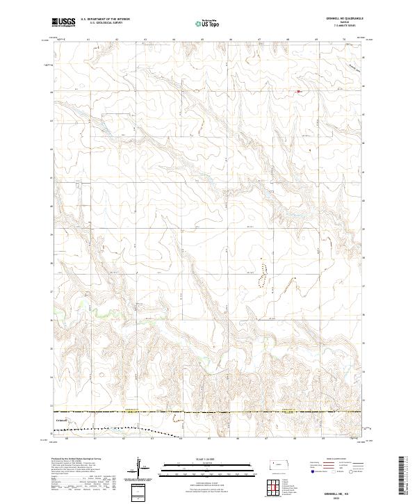
2022 Map of Grinnell NE
USGS Topo · Published 2022About this map
The Saline River cuts through the high plains of northwest Kansas in this contemporary survey, illustrating the characteristic drainage patterns of the region. The landscape is defined by the intersection of the Sheridan Co Gove Co line and a rigorous grid of section lines and gravel roads, including RD 160 S and RD 80 S. In the southwest corner, the edge of Grinnell sits near the headwaters of the N Fork Big Cr, marking the transition from the upland divide to the river valleys.
Find a feature on this map
20 named features on this map. Tap any name to fly to it.
Don’t see what you’re looking for? This feature index may not catch every label — zoom into the map to look around manually.
Map Details
Editions of this 2022 Grinnell NE Map
This is the sole edition of this map. No revisions or reprints were ever made.
Other maps of this area

1954 · Goodland
USGS Topo · 1:250,000

1956 · Goodland
USGS Topo · 1:250,000

1957 · Goodland
USGS Topo · 1:250,000

1979 · Menlo
USGS Topo · 1:24,000

1979 · Midway Draw West
USGS Topo · 1:24,000
1979 · Grainfield
USGS Topo · 1:24,000

1979 · Hoxie
USGS Topo · 1:24,000
1979 · Grinnell South
USGS Topo · 1:24,000

1979 · Grinnell NE
USGS Topo · 1:24,000
1979 · Sunny Slope Lake
USGS Topo · 1:24,000