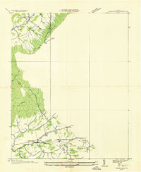
1935 Map of Groseclose
USGS Topo · Published 1935About this map
The Middle Fork Holston River corridor in Southwest Virginia presents a landscape defined by parallel ridges and fertile valleys during the mid-1930s. This survey, conducted by the Tennessee Valley Authority in collaboration with the USGS, highlights the transportation spine of the region where the Norfolk and Western railway and the Lee Highway (U.S. No. 11) run side-by-side through Groseclose. The map documents the rural infrastructure of Wythe County, showing the placement of community hubs such as Bethany Ch and Pleasant Hill Ch, alongside the Green Mountain Sch and Murpheyville Sch. Significant terrain features like Walker Mountain separate Rich Valley from the surrounding lowlands, while family-named hollows and branches like Deckard Hollow and Vaught Br indicate the deeply rooted local settlement patterns of the era.
Find a feature on this map
36 named features on this map. Tap any name to fly to it.
Don’t see what you’re looking for? This feature index may not catch every label — zoom into the map to look around manually.
Map Details
Editions of this 1935 Groseclose Map
This is the sole edition of this map. No revisions or reprints were ever made.
Other maps of this area

1887 · Pocahontas
USGS Topo · 1:125,000

1889 · Wytheville
USGS Topo · 1:125,000

1891 · Pocahontas
USGS Topo · 1:125,000

1892 · Wytheville
USGS Topo · 1:125,000

1894 · Pocahontas
USGS Topo · 1:125,000

1895 · Pocahontas
USGS Topo · 1:125,000

1930 · Speedwell
USGS Topo · 1:62,500

1931 · Rural Retreat
USGS Topo · 1:48,000

1935 · Nebo
USGS Topo · 1:24,000

1935 · Cedar Springs
USGS Topo · 1:24,000