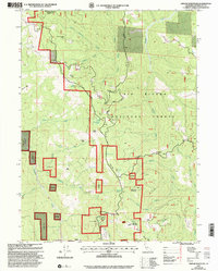
1997 Map of Grouse Mountain
USGS Topo · Published 2001About this map
Six Rivers National Forest lands dominate this late-twentieth-century landscape, where rugged ridgelines and isolated water sources dictate the placement of human activity. The presence of Horse Mountain Mine near the northern border and the Grouse Mountain Lookout at the southern edge suggest a history of resource extraction and fire surveillance. The terrain is marked by family-named landmarks and homestead-style markers, including Janes Place, McMillion Cabin, and Bartlett Ranch, which anchor the map's genealogy interest.
Find a feature on this map
42 named features on this map. Tap any name to fly to it.
Don’t see what you’re looking for? This feature index may not catch every label — zoom into the map to look around manually.
Map Details
Editions of this 1997 Grouse Mountain Map
This is the sole edition of this map. No revisions or reprints were ever made.
Other maps of this area

1914 · Pilot Creek
USGS Topo · 1:62,500

1915 · Big Bar and Vicinity
USGS Topo · 1:250,000

1922 · Korbel
USGS Topo · 1:62,500

1922 · China Flat
USGS Topo · 1:62,500

1922 · Kneeland
USGS Topo · 1:62,500

1945 · Blue Lake
USGS Topo · 1:62,500

1950 · Iaqua Buttes
USGS Topo · 1:62,500

1951 · Pilot Creek
USGS Topo · 1:62,500

1951 · Blue Lake
USGS Topo · 1:62,500

1952 · Willow Creek
USGS Topo · 1:62,500