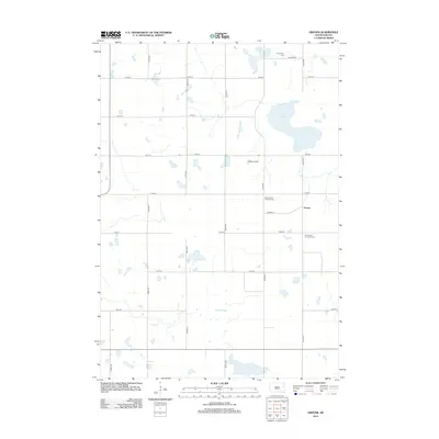
2012 Map of Grover
USGS Topo · Published 2012About this map
The small unincorporated community of Grover anchors this agricultural landscape in Hamlin County, where the township is defined by a rigorous section-line road grid and scattered glacial wetlands. Faith and family history are preserved through the presence of several religious landmarks, including Saint Peter's Catholic Cem and Emmanuel Lutheran Cem just south of the settlement. These sites, along with the Kampeska Cem to the north, provide essential points of reference for genealogists tracing early prairie families. The natural geography is characterized by the expansive waters of Goose Lake and the marshy reaches of Baxter Slough, which break up the geometric pattern of the surrounding fields. Local commerce and land use are reflected in more modern developments like the DeBerg Feedlot, illustrating the area's continued reliance on large-scale ranching and farming operations.
Find a feature on this map
25 named features on this map. Tap any name to fly to it.
Don’t see what you’re looking for? This feature index may not catch every label — zoom into the map to look around manually.
Map Details
Editions of this 2012 Grover Map
This is the sole edition of this map. No revisions or reprints were ever made.
Other maps of this area

1953 · Watertown
USGS Topo · 1:250,000

1958 · Watertown
USGS Topo · 1:250,000

1969 · Hayti
USGS Topo · 1:24,000

1969 · Watertown West
USGS Topo · 1:24,000

1969 · Pelican Lake
USGS Topo · 1:24,000
1973 · Henry
USGS Topo · 1:24,000

1973 · Bryant NE
USGS Topo · 1:24,000
1973 · Kampeska
USGS Topo · 1:24,000
1973 · Grover
USGS Topo · 1:24,000

1973 · Vienna East
USGS Topo · 1:24,000