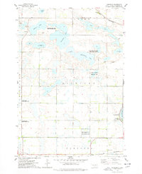
1973 Map of Kampeska
USGS Topo · Published 1978About this map
Lake Kampeska anchors the eastern edge of this landscape in the early 1970s, surrounded by a complex network of glacial wetlands and managed conservation lands. The area is characterized by a significant concentration of public grounds, including the Horseshoe Lake State Public Shooting Area and the National Waterfowl Production Area, reflecting the region's importance for migratory birds and local sporting traditions. Small clusters of development appear at Watertown and the settlement of Kampeska, while the Chicago and North Western railroad cuts across the northern and southern reaches of the quadrangle. The terrain is dotted with numerous bodies of water like Medicine Lake and the Chain of Lakes, as well as several Gravel Pits that suggest the local extraction industries supporting the road network of Richland and Kampeska townships.
Find a feature on this map
26 named features on this map. Tap any name to fly to it.
Don’t see what you’re looking for? This feature index may not catch every label — zoom into the map to look around manually.
Map Details
Editions of this 1973 Kampeska Map
This is the sole edition of this map. No revisions or reprints were ever made.
Other maps of this area

1953 · Milbank
USGS Topo · 1:250,000

1953 · Watertown
USGS Topo · 1:250,000

1958 · Milbank
USGS Topo · 1:250,000

1958 · Watertown
USGS Topo · 1:250,000

1969 · Watertown West
USGS Topo · 1:24,000

1969 · Pelican Lake
USGS Topo · 1:24,000

1970 · Still Lake
USGS Topo · 1:24,000

1973 · Florence
USGS Topo · 1:24,000

1973 · Wallace
USGS Topo · 1:24,000
1973 · Henry
USGS Topo · 1:24,000