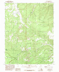
1985 Map of Grover
USGS Topo · Published 1985About this map
The small high-elevation settlement of Grover sits at the northern edge of this 1985 survey, positioned between the steep slopes of Boulder Mountain and the expansive heights of Miners Mountain. This landscape is defined by the transition from the Dixie National Forest into the red-rock reaches of Capitol Reef National Park in the northeast corner. The map reveals a land utilized for both its natural resources and livestock grazing, evidenced by features such as a mine shaft on the mountain slopes and specialized terrain like Rock Creek Meadow and Chokecherry Meadow.
Find a feature on this map
34 named features on this map. Tap any name to fly to it.
Don’t see what you’re looking for? This feature index may not catch every label — zoom into the map to look around manually.
Map Details
Editions of this 1985 Grover Map
2 editions found
Other maps of this area

1885 · Fish Lake
USGS Topo · 1:250,000

1896 · Fish Lake
USGS Topo · 1:250,000

1952 · Notom 3 SW
USGS Topo · 1:24,000

1952 · Notom 3 NW
USGS Topo · 1:24,000

1952 · Notom 2 SE
USGS Topo · 1:24,000

1952 · Notom 2 SW
USGS Topo · 1:24,000

1952 · Notom 4 NW
USGS Topo · 1:24,000

1952 · Notom 4 SW
USGS Topo · 1:24,000

1952 · Notom 3 SE
USGS Topo · 1:24,000

1952 · Notom 3 NE
USGS Topo · 1:24,000