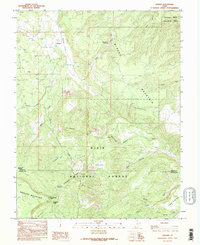
1985 Map of Grover
USGS Topo · Published 1995About this map
Grover sits at the northern edge of this high-altitude landscape where the southern border of Capitol Reef National Park meets the vast expanse of the Dixie National Forest. This 1985 survey, based on field work from the late 1970s, documents a transition from the structured drainages of Carcass Creek and Sulphur Creek to the high plateaus of Boulder Mountain. Human presence is marked by isolated mountain outposts like Chokecherry Meadow and Rock Creek Meadow, alongside evidence of resource extraction at the Borrow Pit, Mine Shaft, and various prospects on Miners Mountain. The terrain is defined by dramatic geologic features such as Devils Slide, The Terrace, and the sweeping Pleasant Creek Flats near Jorgenson Flat, providing a detailed record of the trails and 4WD tracks used by ranchers and miners before more modern developments shaped the region.
Find a feature on this map
34 named features on this map. Tap any name to fly to it.
Don’t see what you’re looking for? This feature index may not catch every label — zoom into the map to look around manually.
Map Details
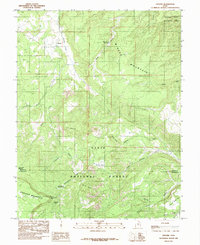
Editions of this 1985 Grover Map
2 editions found
Other maps of this area

1885 · Fish Lake
USGS Topo · 1:250,000

1896 · Fish Lake
USGS Topo · 1:250,000

1952 · Notom 3 SW
USGS Topo · 1:24,000

1952 · Notom 3 NW
USGS Topo · 1:24,000

1952 · Notom 2 SE
USGS Topo · 1:24,000

1952 · Notom 2 SW
USGS Topo · 1:24,000

1952 · Notom 4 NW
USGS Topo · 1:24,000

1952 · Notom 4 SW
USGS Topo · 1:24,000

1952 · Notom 3 SE
USGS Topo · 1:24,000

1952 · Notom 3 NE
USGS Topo · 1:24,000