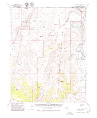
1953 Map of The Spur
USGS Topo · Published 1979About this map
Tidwell Ranch and a remote network of jeep trails define this arid landscape along the Green River during the early 1950s. The map illustrates a complex geography of high mesas and deep drainage systems, including the massive Orange Cliffs and The Spur. Evidence of ancient habitation is noted with Pictographs in Barrier Canyon, while more recent activity is marked by a Drill Hole and various springs like Wildcat Spring and Outlaw Spring. The terrain is split between the newly established Canyonlands National Park and the Glen Canyon National Recreation Area. From the sheer walls of Labyrinth Canyon to the broad Upper Pasture, the survey provides a detailed record of this corner of Wayne County before modern paved access reached these isolated benches.
Find a feature on this map
63 named features on this map. Tap any name to fly to it.
Don’t see what you’re looking for? This feature index may not catch every label — zoom into the map to look around manually.
Map Details
Editions of this 1953 The Spur Map
4 editions found

Other maps of this area

1885 · San Rafael
USGS Topo · 1:250,000

1885 · La Sal
USGS Topo · 1:250,000

1951 · The Knoll
USGS Topo · 1:62,500

1951 · Upheaval Dome
USGS Topo · 1:62,500

1952 · Tidwell 4 SE
USGS Topo · 1:24,000

1952 · Carlisle 2 NW
USGS Topo · 1:24,000

1952 · Carlisle 2 SW
USGS Topo · 1:24,000

1952 · Moab 3 SW
USGS Topo · 1:24,000

1953 · Carlisle 3 NW
USGS Topo · 1:24,000

1953 · Orange Cliffs 1 SE
USGS Topo · 1:24,000