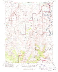
1953 Map of The Spur
USGS Topo · Published 1971About this map
Tidwell Ranch and the remote outposts of The Mailbox and Red Nubs stand as isolated signs of human activity in this mid-century survey of the canyon country where Wayne, Emery, and San Juan Counties meet. The landscape is defined by the winding course of the Green River as it carves through Stillwater Canyon, creating dramatic river bends such as Bonita Bend and low-lying areas like Anderson Bottom and Potato Bottom. Dramatic geological formations dominate the topography, including the towering Orange Cliffs, the distinctive Buttes of the Cross, and Cleopatras Chair. Navigation through this complex system of breaks and plateaus is mapped via a network of jeep trails and routes crossing the Millard Canyon Benches, revealing how early explorers and ranchers accessed the Head of the Spur and the surrounding desert wilderness.
Find a feature on this map
64 named features on this map. Tap any name to fly to it.
Don’t see what you’re looking for? This feature index may not catch every label — zoom into the map to look around manually.
Map Details
Editions of this 1953 The Spur Map
4 editions found

Other maps of this area

1885 · San Rafael
USGS Topo · 1:250,000

1885 · La Sal
USGS Topo · 1:250,000

1951 · The Knoll
USGS Topo · 1:62,500

1951 · Upheaval Dome
USGS Topo · 1:62,500

1952 · Tidwell 4 SE
USGS Topo · 1:24,000

1952 · Carlisle 2 NW
USGS Topo · 1:24,000

1952 · Carlisle 2 SW
USGS Topo · 1:24,000

1952 · Moab 3 SW
USGS Topo · 1:24,000

1953 · Carlisle 3 NW
USGS Topo · 1:24,000

1953 · Orange Cliffs 1 SE
USGS Topo · 1:24,000