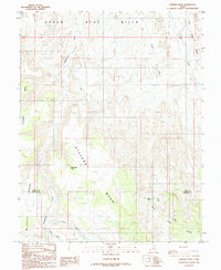
1986 Map of Stevens Mesa
USGS Topo · Published 1987About this map
Stevens Mesa and Wildcat Mesa dominate this section of the Colorado Plateau, where the high desert landscape is defined by massive landforms and a scarce but vital water network. This 1980s U.S. Geological Survey provisional map documents a transition in geography across the boundary of Wayne and Garfield counties. While the Upper Blue Hills rise to the north, the drainage patterns of Sweetwater Creek, Oak Creek, and Cedar Creek carve deep into the plateau's edges. Strategic water sources like Indianwater Seep and Maidenwater Spring are clearly marked, providing critical reference points for historical land use in an area otherwise characterized by intermittent flows such as Dry Wash and Dugout Creek. The map effectively captures the isolated character of Thompson Mesa and the lower Bench areas before modern development or major shifts in land management.
Find a feature on this map
13 named features on this map. Tap any name to fly to it.
Don’t see what you’re looking for? This feature index may not catch every label — zoom into the map to look around manually.
Map Details
Editions of this 1986 Stevens Mesa Map
This is the sole edition of this map. No revisions or reprints were ever made.
Other maps of this area

1885 · San Rafael
USGS Topo · 1:250,000

1885 · Fish Lake
USGS Topo · 1:250,000

1896 · Fish Lake
USGS Topo · 1:250,000

1952 · Notom 4 SE
USGS Topo · 1:24,000

1952 · Notom 4 NE
USGS Topo · 1:24,000

1952 · Notom
USGS Topo · 1:62,500

1954 · Mt. Ellen 2 SE
USGS Topo · 1:24,000

1954 · Mt. Ellen 2 SW
USGS Topo · 1:24,000

1954 · Fruita
USGS Topo · 1:62,500
1954 · Notom 1 SE
USGS Topo · 1:24,000