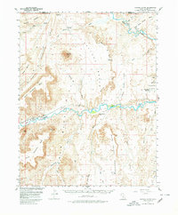
1954 Map of Factory Butte
USGS Topo · Published 1980About this map
The rugged badlands of Blue Valley and the prominent Factory Butte dominate this 1950s survey of south-central Utah. The map documents an arid landscape shaped by the Fremont River and the Muddy River, where human endeavor is marked by the Blue Gate Canal and the isolated Coal Mine near the Caineville Reef. At the center of the Fremont Valley lies Giles, a small settlement situated near Steamboat Point, providing a window into the sparse habitation of Wayne County during the mid-20th century.
Find a feature on this map
38 named features on this map. Tap any name to fly to it.
Don’t see what you’re looking for? This feature index may not catch every label — zoom into the map to look around manually.
Map Details
Editions of this 1954 Factory Butte Map
3 editions found

Other maps of this area

1885 · San Rafael
USGS Topo · 1:250,000

1885 · Fish Lake
USGS Topo · 1:250,000

1896 · Fish Lake
USGS Topo · 1:250,000

1952 · Notom 4 NE
USGS Topo · 1:24,000

1952 · Mt. Ellen 4 NW
USGS Topo · 1:24,000

1952 · Bull Mountain
USGS Topo · 1:62,500

1952 · Wild Horse
USGS Topo · 1:62,500

1952 · Notom
USGS Topo · 1:62,500

1953 · Emery 4 SE
USGS Topo · 1:24,000

1953 · Temple Mtn
USGS Topo · 1:62,500