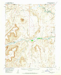
1954 Map of Factory Butte
USGS Topo · Published 1963About this map
Factory Butte dominates the center of this high-desert landscape in Wayne County, which was surveyed during a period of active mineral exploration in the mid-1950s. The presence of the Factory Butte Coal Mine near Coal Mine Wash and the cooperation of the Atomic Energy Commission in the map's production suggest the industrial and strategic importance of the region during the Cold War era. The Fremont River meanders across the southern half of the sheet, where the settlement of Giles once sat as a pocket of habitation amidst the massive geological formations of the Blue Hills and the North Caineville Mesa. Travel through the area is marked by the rugged Caineville Trail and various jeep trails, highlighting the challenges of traversing the Caineville Reef and the expansive Factory Bench. Drainage systems like Muddy River and Salt Wash define the erosional patterns of the terrain, while landmarks such as Steamboat Point and White Point provide critical orientation points in this sparse, arid environment.
Find a feature on this map
44 named features on this map. Tap any name to fly to it.
Don’t see what you’re looking for? This feature index may not catch every label — zoom into the map to look around manually.
Map Details
Editions of this 1954 Factory Butte Map
3 editions found

Other maps of this area

1885 · San Rafael
USGS Topo · 1:250,000

1885 · Fish Lake
USGS Topo · 1:250,000

1896 · Fish Lake
USGS Topo · 1:250,000

1952 · Notom 4 NE
USGS Topo · 1:24,000

1952 · Mt. Ellen 4 NW
USGS Topo · 1:24,000

1952 · Bull Mountain
USGS Topo · 1:62,500

1952 · Wild Horse
USGS Topo · 1:62,500

1952 · Notom
USGS Topo · 1:62,500

1953 · Emery 4 SE
USGS Topo · 1:24,000

1953 · Temple Mtn
USGS Topo · 1:62,500