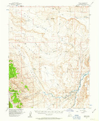
1954 Map of Fruita
USGS Topo · Published 1963About this map
Capitol Reef National Monument dominates the southwestern quadrant of this mid-century survey, documenting the early geography of the park before its later expansion. The settlement of Fruita serves as a primary reference point along the Fremont River, positioned near prominent landmarks such as Hickman Natural Bridge and Chimney Rock. The landscape transitions from the high elevations of Miners Mtn and Danish Hill into the striking geological formations of The South Hartnet and the massive Middle Desert. To the east, the topography is defined by the Caineville Reef and the long stretch of Caineville Mesa. Evidence of early agricultural and water management efforts is visible through the North Caineville Reef Ditch and its Siphon near the river. Remote reaches like Cathedral Valley and Moroni Slopes highlight the vast, unpopulated character of the Wayne County backcountry in the 1950s.
Find a feature on this map
60 named features on this map. Tap any name to fly to it.
Don’t see what you’re looking for? This feature index may not catch every label — zoom into the map to look around manually.
Map Details
Editions of this 1954 Fruita Map
2 editions found

Other maps of this area

1885 · San Rafael
USGS Topo · 1:250,000

1885 · Fish Lake
USGS Topo · 1:250,000

1896 · Fish Lake
USGS Topo · 1:250,000

1952 · Notom 2 SE
USGS Topo · 1:24,000

1952 · Notom 4 NW
USGS Topo · 1:24,000

1952 · Notom 4 NE
USGS Topo · 1:24,000

1952 · Notom 2 NE
USGS Topo · 1:24,000

1952 · Notom 3 NE
USGS Topo · 1:24,000

1952 · Notom 1 SW
USGS Topo · 1:24,000

1952 · Grover
USGS Topo · 1:62,500