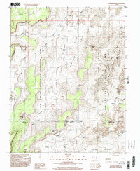
1996 Map of Elaterite Basin
USGS Topo · Published 2002About this map
Elaterite Basin and the surrounding high desert canyon country are defined by a complex network of sheer sandstone walls and deep drainages along the border of Wayne and Garfield Counties. In the mid-1990s, this area remained an incredibly primitive landscape, split between the Glen Canyon National Recreation Area and the labyrinthine Canyonlands National Park The Maze. The survey documents a wilderness accessible primarily via 4WD tracks and foot trails, such as the West Fork North Trail Canyon.
Find a feature on this map
32 named features on this map. Tap any name to fly to it.
Don’t see what you’re looking for? This feature index may not catch every label — zoom into the map to look around manually.
Map Details
Editions of this 1996 Elaterite Basin Map
This is the sole edition of this map. No revisions or reprints were ever made.
Other maps of this area

1885 · San Rafael
USGS Topo · 1:250,000

1885 · La Sal
USGS Topo · 1:250,000

1951 · Upheaval Dome
USGS Topo · 1:62,500

1952 · Carlisle 2 SW
USGS Topo · 1:24,000

1953 · Carlisle 3 NW
USGS Topo · 1:24,000

1953 · Orange Cliffs 1 SE
USGS Topo · 1:24,000

1953 · Orange Cliffs 4 NW
USGS Topo · 1:24,000

1953 · Orange Cliffs 4 NE
USGS Topo · 1:24,000

1953 · Orange Cliffs 4 SW
USGS Topo · 1:24,000

1953 · The Spur
USGS Topo · 1:62,500