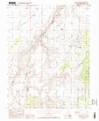
1988 Map of Sugarloaf Butte
USGS Topo · Published 1988About this map
Canyonlands National Park and the Glen Canyon National Recreation Area converge in this high desert landscape, defined by deep drainage systems and prominent mesas. The terrain is marked by the massive plateau of The Spur and the descent into Antelope Valley, with travel limited to a singular Foot Trail and primitive 4WD routes. Archaeological and recreational interest is centered around the Horseshoe Canyon Unit Campground, where Pictographs and the Horseshoe Barrier indicate a long history of human presence in this arid environment.
Find a feature on this map
19 named features on this map. Tap any name to fly to it.
Don’t see what you’re looking for? This feature index may not catch every label — zoom into the map to look around manually.
Map Details
Editions of this 1988 Sugarloaf Butte Map
This is the sole edition of this map. No revisions or reprints were ever made.
Other maps of this area

1885 · San Rafael
USGS Topo · 1:250,000

1952 · Tidwell 4 SE
USGS Topo · 1:24,000

1953 · Orange Cliffs 1 SE
USGS Topo · 1:24,000

1953 · Orange Cliffs 1 NE
USGS Topo · 1:24,000

1953 · The Spur
USGS Topo · 1:62,500

1956 · Salina
USGS Topo · 1:250,000

1960 · Salina
USGS Topo · 1:250,000

1962 · Salina
USGS Topo · 1:250,000

1963 · Robbers Roost Canyon
USGS Topo · 1:62,500
1963 · Bowknot Bend
USGS Topo · 1:62,500