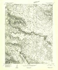
1954 Map of Notom 1 NW
USGS Topo · Published 1957About this map
Salt Wash winds through the high desert landscape of central Utah in this 1954 topographic survey, revealing a drainage system defined by intermittent water sources and dramatic elevation changes. The map captures a transition point between the Emery and Wayne county lines, where the vast drainage of Hartnet Draw converges toward the deeper incision of Deep Creek. Evidence of the area's scarce but vital water resources is noted by Campers Spring and several identified Seeps, which likely served as critical stopping points for travelers and livestock moving through this arid environment. The intricate contour lines illustrate a terrain of complex plateaus and erosional breaks, typical of the Colorado Plateau's geomorphology.
Find a feature on this map
8 named features on this map. Tap any name to fly to it.
Don’t see what you’re looking for? This feature index may not catch every label — zoom into the map to look around manually.
Map Details
Editions of this 1954 Notom 1 NW Map
This is the sole edition of this map. No revisions or reprints were ever made.
Other maps of this area

1885 · Fish Lake
USGS Topo · 1:250,000

1896 · Fish Lake
USGS Topo · 1:250,000

1952 · Notom 2 SE
USGS Topo · 1:24,000

1952 · Notom 2 NE
USGS Topo · 1:24,000

1952 · Notom 1 SW
USGS Topo · 1:24,000

1952 · Torrey
USGS Topo · 1:62,500

1953 · Emery 4 SE
USGS Topo · 1:24,000

1954 · Notom 1 NE
USGS Topo · 1:24,000

1954 · Fruita
USGS Topo · 1:62,500
1954 · Notom 1 SE
USGS Topo · 1:24,000