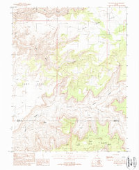
1988 Map of The Pinnacle
USGS Topo · Published 1988About this map
Sams Mesa and the surrounding high desert terrain define this late 20th-century survey along the border of Wayne and Garfield Counties. The landscape is dominated by a complex network of deep drainage systems, most notably Twin Corral Box Canyon and the expansive Box Canyon to the south. A prominent landmark, The Pinnacle, stands as a geographic anchor amidst the mesas and ridges. This provisional edition, based on 1981 aerial photography, details a remote region where water sources like Dripping Spring and Two Pipe Spring were critical for cattle ranching or transit through the high Big Ridge. The presence of labels like Corral and Flats underscores the historical use of this territory for grazing, while the lack of established towns highlights the area's isolation within the canyon country.
Find a feature on this map
14 named features on this map. Tap any name to fly to it.
Don’t see what you’re looking for? This feature index may not catch every label — zoom into the map to look around manually.
Map Details
Editions of this 1988 The Pinnacle Map
This is the sole edition of this map. No revisions or reprints were ever made.
Other maps of this area

1885 · San Rafael
USGS Topo · 1:250,000

1952 · Orange Cliffs 3 SW
USGS Topo · 1:24,000

1953 · Orange Cliffs 3 SE
USGS Topo · 1:24,000

1953 · Orange Cliffs 4 NW
USGS Topo · 1:24,000

1953 · Orange Cliffs 3 NE
USGS Topo · 1:24,000

1953 · Orange Cliffs 4 SW
USGS Topo · 1:24,000

1953 · Orange Cliffs 3 NW
USGS Topo · 1:24,000

1953 · The Spur
USGS Topo · 1:62,500

1953 · Fiddler Butte
USGS Topo · 1:62,500

1953 · Orange Cliffs
USGS Topo · 1:62,500