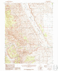
1987 Map of Fruita
USGS Topo · Published 1987About this map
Fruita sits at the confluence of Sulphur Creek and the Fremont River, serving as a pocket of settlement within the expansive reach of Capitol Reef National Park. This 1987 survey details the complex geological formations of the Waterpocket Fold and the South Desert, where the landscape is defined by deep canyons and high mesas. The presence of Petroglyphs near the river indicates the long-standing human history of the area, while the Hickman Natural Bridge Trail leads to the prominent Hickman Natural Bridge. To the south and east, the terrain breaks into landmarks like Danish Hill and The Narrows, illustrating the difficult travel corridors through the monocline. The map also records early water management features such as a Levee along the river and various spring-fed systems like Spring Canyon.
Find a feature on this map
26 named features on this map. Tap any name to fly to it.
Don’t see what you’re looking for? This feature index may not catch every label — zoom into the map to look around manually.
Map Details
Editions of this 1987 Fruita Map
2 editions found
Other maps of this area

1885 · Fish Lake
USGS Topo · 1:250,000

1896 · Fish Lake
USGS Topo · 1:250,000

1952 · Notom 2 SE
USGS Topo · 1:24,000

1952 · Notom 4 NW
USGS Topo · 1:24,000

1952 · Notom 4 NE
USGS Topo · 1:24,000

1952 · Notom 2 NE
USGS Topo · 1:24,000

1952 · Notom 3 NE
USGS Topo · 1:24,000

1952 · Notom 1 SW
USGS Topo · 1:24,000

1952 · Grover
USGS Topo · 1:62,500

1952 · Torrey
USGS Topo · 1:62,500