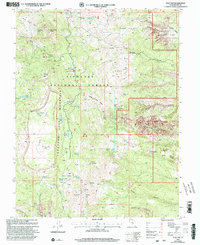
2001 Map of Flat Top
USGS Topo · Published 2003About this map
Thousand Lake Mountain dominates the western half of this landscape, its high plateau punctuated by Flat Top and several distinct alpine water bodies including Deep Creek Lake and Snow Lake. The transition from the high Fishlake National Forest eastward reveals the dramatic geology of the Waterpocket Fold, where the terrain drops sharply into the canyons of Capitol Reef National Park. This 2001 revision illustrates a complex hydrological network of springs and reservoirs, such as Neff Reservoir and Round Lake, which supported local grazing in areas like Wiffs Pasture and Paradise Flats. The map provides a detailed record of high-altitude forest management and conservation at the dawn of the 21st century, centering on the Elkhorn Campground and the numerous named springs that feed the drainages of Sulphur Creek and Polk Creek.
Find a feature on this map
60 named features on this map. Tap any name to fly to it.
Don’t see what you’re looking for? This feature index may not catch every label — zoom into the map to look around manually.
Map Details
Editions of this 2001 Flat Top Map
This is the sole edition of this map. No revisions or reprints were ever made.
Other maps of this area

1885 · Fish Lake
USGS Topo · 1:250,000

1896 · Fish Lake
USGS Topo · 1:250,000

1952 · Notom 2 NW
USGS Topo · 1:24,000

1952 · Loa 1 SE
USGS Topo · 1:24,000

1952 · Notom 2 SE
USGS Topo · 1:24,000

1952 · Notom 2 SW
USGS Topo · 1:24,000

1952 · Notom 2 NE
USGS Topo · 1:24,000

1952 · Torrey
USGS Topo · 1:62,500

1952 · Loa 1 NE
USGS Topo · 1:24,000

1956 · Salina
USGS Topo · 1:250,000