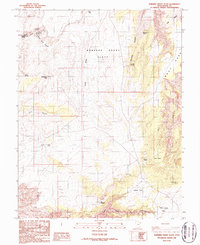
1986 Map of Robbers Roost Flats
USGS Topo · Published 1987About this map
Robbers Roost Flats dominates the center of this high-desert landscape in Utah’s Wayne County, characterized by a complex network of plateaus and deep incisions. The area’s hydrology is defined by critical water sources such as Bluejohn Spring, Silvertip Spring, and South Robbers Roost Spring, which supported livestock and travelers in this arid terrain. Topographical landmarks like The Pinnacles and Deadman Hill provide vertical orientation amidst the sprawling Goat Park and Coyote Flat.
Find a feature on this map
25 named features on this map. Tap any name to fly to it.
Don’t see what you’re looking for? This feature index may not catch every label — zoom into the map to look around manually.
Map Details
Editions of this 1986 Robbers Roost Flats Map
This is the sole edition of this map. No revisions or reprints were ever made.
Other maps of this area

1885 · San Rafael
USGS Topo · 1:250,000

1953 · Orange Cliffs 4 NW
USGS Topo · 1:24,000

1953 · Orange Cliffs 3 NE
USGS Topo · 1:24,000

1953 · Orange Cliffs 3 NW
USGS Topo · 1:24,000

1953 · The Spur
USGS Topo · 1:62,500

1953 · Fiddler Butte
USGS Topo · 1:62,500

1953 · Orange Cliffs
USGS Topo · 1:62,500

1956 · Salina
USGS Topo · 1:250,000

1960 · Salina
USGS Topo · 1:250,000

1962 · Salina
USGS Topo · 1:250,000