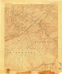
1892 Map of Grundy
USGS Topo · Published 1903About this map
The Kentucky Virginia Boundary Line bisects this late nineteenth-century reconnaissance, marking the divide between Pike County, Kentucky, and the Virginia counties of Buchanan, Dickenson, Wise, and Russell. The landscape is dominated by the steep dissection of the Cumberland Plateau, where the Russell Fork carves through the dramatic geological feature known as The Breaks. This survey, conducted in the 1880s, reveals a remote Appalachian region defined by its narrow valley settlements and extensive stream networks. Small mountain communities and early post offices like Grundy, Clintwood, and Jamboree are connected by rugged terrain rather than established rail lines. Prominent landmarks such as Pine Mountain and Big Butt overlook a complex watershed including the Pound River and Elkhorn Creek, illustrating the drainage patterns that dictated the placement of homesteads and early roads before the era of industrial coal expansion.
Find a feature on this map
96 named features on this map. Tap any name to fly to it.
Don’t see what you’re looking for? This feature index may not catch every label — zoom into the map to look around manually.
Map Details
Editions of this 1892 Grundy Map
4 editions found
Other maps of this area

1886 · Prestonsburg
USGS Topo · 1:125,000

1886 · Grundy
USGS Topo · 1:125,000

1887 · Warfield
USGS Topo · 1:125,000

1890 · Whitesburg
USGS Topo · 1:125,000

1890 · Grundy
USGS Topo · 1:125,000

1891 · Tazewell
USGS Topo · 1:125,000

1891 · Oceana
USGS Topo · 1:125,000

1891 · Abingdon
USGS Topo · 1:125,000

1891 · Warfield
USGS Topo · 1:125,000

1892 · Grundy
USGS Topo · 1:125,000