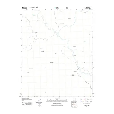
2011 Map of Guadalupe
USGS Topo · Published 2011About this map
The settlement of Guadalupe and its Guadalupe Historic District anchor this desert landscape along the winding course of the Rio Puerco. This 2011 map reveals a region defined by scattered springs and volcanic landforms, with the Guadalupe Cemetery and the tiny settlement of Loddy positioned east of the river. The topography is dominated by prominent volcanic features like Cerro de Guadalupe and Cerro Salado, while seasonal water sources such as Aranda Tank and Ojo del Padre suggest the historical reliance on intermittent water in this arid environment. Roads like Guadalupe Rd and San Luis Rd provide the primary access through the canyon and mesa country, connecting isolated landmarks such as the Cirillio Garcia Detention Dam to the river valley floor.
Find a feature on this map
34 named features on this map. Tap any name to fly to it.
Don’t see what you’re looking for? This feature index may not catch every label — zoom into the map to look around manually.
Map Details
Editions of this 2011 Guadalupe Map
This is the sole edition of this map. No revisions or reprints were ever made.
Other maps of this area

1883 · Mt. Taylor
USGS Topo · 1:250,000

1886 · Mt. Taylor
USGS Topo · 1:250,000

1892 · Mt. Taylor
USGS Topo · 1:250,000

1899 · Mt. Taylor
USGS Topo · 1:250,000

1958 · Albuquerque
USGS Topo · 1:250,000

1961 · Cerro Parido
USGS Topo · 1:24,000

1961 · Cerro Tinaja
USGS Topo · 1:24,000

1961 · Arroyo Empedrado
USGS Topo · 1:24,000
1961 · Canada Calladita
USGS Topo · 1:24,000
1961 · Laguna Seca
USGS Topo · 1:24,000