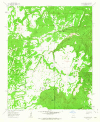
1961 Map of Laguna Seca
USGS Topo · Published 1963About this map
Cibola National Forest encompasses this high-altitude landscape on the boundary of McKinley and Sandoval counties as it appeared in the early 1960s. The terrain is defined by deep canyons and prominent mesas, notably the expansive Mesa de la Vereda Piedra Blanca and Valle de las Animas. Small settlements and named locales like La Jolla de Santa Rosa and Eagle Nest suggest a history of localized grazing or ranching, supported by a network of water sources including Guadalupe Spring and Laguna Seca. The presence of the Guadalupe Ranger Station indicates the importance of federal land management in this era. The map also records the complex historical land divisions through labels such as the Grant Boundary and the long-named Nuestra Señora de la Luz de las Lagunitas, which reflect New Mexico's deep Spanish land grant heritage.
Find a feature on this map
40 named features on this map. Tap any name to fly to it.
Don’t see what you’re looking for? This feature index may not catch every label — zoom into the map to look around manually.
Map Details
Editions of this 1961 Laguna Seca Map
2 editions found
Other maps of this area

1883 · Mt. Taylor
USGS Topo · 1:250,000

1886 · Mt. Taylor
USGS Topo · 1:250,000

1892 · Mt. Taylor
USGS Topo · 1:250,000

1899 · Mt. Taylor
USGS Topo · 1:250,000

1958 · Albuquerque
USGS Topo · 1:250,000

1961 · Marquez
USGS Topo · 1:24,000

1961 · Cerro Parido
USGS Topo · 1:24,000

1961 · Cerro Tinaja
USGS Topo · 1:24,000

1961 · El Dado Mesa
USGS Topo · 1:24,000
1961 · La Gotera
USGS Topo · 1:24,000